
 (480x270)")
Just why has Meaford been hit by so much flooding over the last three months?
Not only is the flooding a nightmare for businesses in the spot that’s worst hit – particularly Meaford Day Nursery and the George and Dragon pub – but the closure of the A34, one of the major arterial routes in Staffordshire, affects thousands of people.
Staffordshire County Council used divers to clear a culvert under the A34 in December. However, many local people have been saying that the problem lies away from the A34 itself, a short distance away on Meaford Road.
Gary Sharman filmed the video below to explain what’s happening.

He said: “There has been a lot of speculation as to what’s been causing the flooding, so it was interesting to see for myself the precise origin of the problem. It would appear that the stream (it’s the same one which cuts through the Downs Banks) which goes under the railway then under the canal (just north of the very end of the Whitebridge housing estate) should then pass through a culvert under Meaford Road and then feed into the small lakes at Meaford Hall which then feeds into the River Trent. That’s what should be happening.
“What has happened is that the culvert under Meaford Road has either caved in or become blocked. The result is that a small lake builds up between the canal and Meaford Road which eventually flows on to Meaford Road when the level gets too high – and down towards the A34. Until the culvert is repaired this flooding will keep happening.”
https://youtu.be/dN-5bfw0M0Y
The issue at Meaford needs fixing as a matter of urgency. I will forward this post to Staffordshire County Council, the Environment Agency and the Canal & River Trust and keep you posted on their responses.
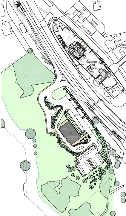
Meanwhile, Neil Harrison produced this map to back up Gary’s explanation:


4 comments
Joe and Jill
thank you for the excellent video and explanation we have lived in Stone for over 40 years and have never witnessed floods like the last o
nes.thanks again. jill and joe Wood
RichardS
Thanks for the video and the map. Although I’ve heard the explanation before, I found it difficult to visualise – now it is so clear and obvious. I’ve lived in Stone and Barlaston for almost sixty years and we’ve never seen his problem before. So whose responsibility is it to rectify the blockage? I feel so sorry for the nursery and the pub.
David Haigh
Water always flows down hill, even when diverted. This is being caused due to the brook being divert to fill the fish pond for Meaford Hall and then the pools for the Lake side Tavern! As it floods it finds the quickest route down which is over a low barrage, and then down the field. The route it should take is through that junction as can be seen from the indent in the contour line (90m) at the junction.